How to Plan the Perfect Day Exploring Greater Sudbury's Scenic Lakes and Trails

This guide breaks down exactly how to plan a full day exploring Greater Sudbury's interconnected network of lakes and trails, covering route logistics, timing, equipment needs, and seasonal considerations. Whether you're a local looking to maximize a Saturday or a visitor planning an itinerary, following this framework ensures you hit the best viewpoints, avoid parking headaches, and finish the day without blistered feet or an empty gas tank.
Morning: Ramsey Lake and the South Shore
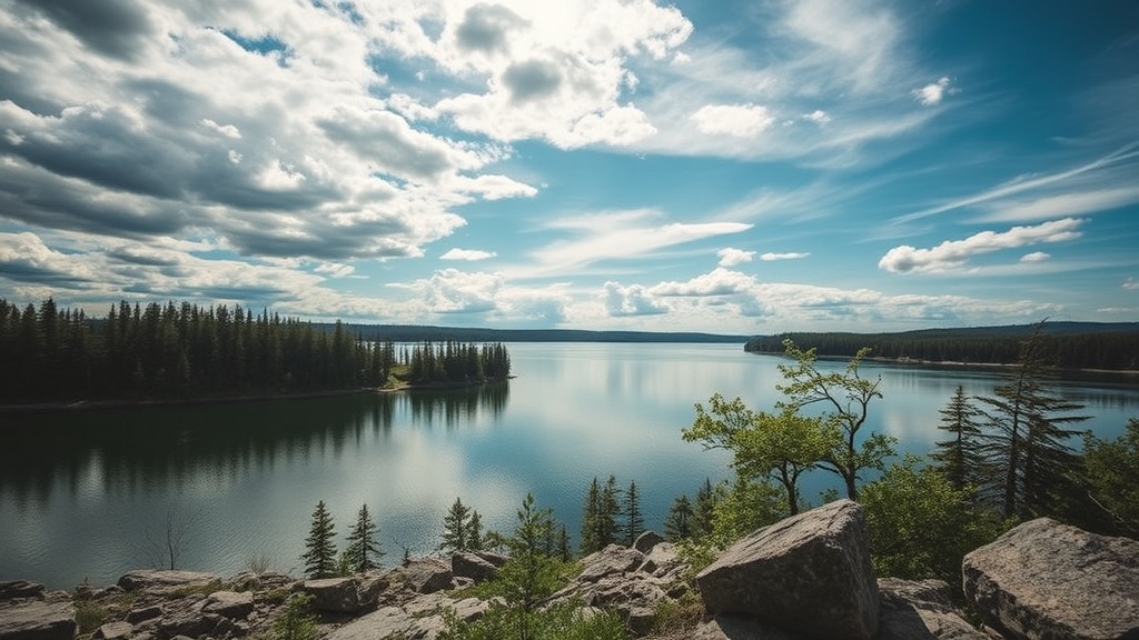
Start at Bell Park (Shannon Road entrance) by 8:00 AM. The main lot fills by 9:30 AM on summer weekends, and the 174 paved parking spaces disappear faster than you'd expect. Ramsey Lake covers 792 hectares, making it the second-largest lake contained entirely within a single Ontario city boundary (after Lake Wanapitei).
Walk the Jimmy C. Drummond Pathway first. This 2.5-kilometre paved route hugs the shoreline from Bell Park to Science North. The pathway averages 3 metres wide, accommodates strollers and wheelchairs, and features 12 interpretive panels describing the region's geological history. Allow 45 minutes at a moderate pace with photo stops.
At Science North, cross the parking lot to reach the Tom Davies Square boardwalk extension. This 800-metre section connects to the Grace Hartman Amphitheatre trailhead. Here's where you pick up the unpaved portion.
The Trans Canada Trail segment running south from Ramsey Lake follows the historic Canadian Pacific Railway bed. Walk 3.2 kilometres to the Fielding Bird Sanctuary overlook. This section features crushed limestone surfacing, minimal elevation gain (only 15 metres over the entire distance), and views across the lake toward the distant smokestack at the Copper Cliff smelter. Budget 90 minutes round-trip from Science North.
Breakfast Stop: The Motley Kitchen
Drive 6 kilometres northwest to The Motley Kitchen on Regent Street South. Opens at 7:00 AM, serves breakfast until 11:00 AM. The Sudbury Breakfast (two eggs, home fries, toast, choice of meat) costs $14.95 and provides sufficient fuel for the hiking ahead. Parking in the rear lot accommodates 18 vehicles.
Midday: Lake Laurentian Conservation Area
From The Motley Kitchen, head 8 kilometres south on Long Lake Road to the Lake Laurentian Conservation Area main entrance. The conservation area encompasses 2,400 hectares of protected green space within city limits. The nature centre parking lot has 45 spaces and serves as the hub for 55 kilometres of marked trails.
Select the Chickadee Ridge Trail for your midday hike. This 5.2-kilometre loop starts at the nature centre, climbs 85 metres to the ridge summit, and descends through mixed hardwood forest. The trail features blue blazes, moderate difficulty due to root sections and one steep 200-metre climb, and takes approximately 2 hours to complete at a steady pace.
The summit clearing at kilometre 2.1 offers a 270-degree view south toward the Lake Huron watershed. On clear days, you can see the distant silhouette of the Niagara Escarpment 40 kilometres away. Bring the binoculars—this spot hosts migrating hawks in April and September.
Pack a lunch rather than backtracking to restaurants. The conservation area's pavilion near the nature centre has 6 picnic tables, potable water from May through October, and washroom facilities. Alternatively, carry sandwiches and eat at the ridge summit—there are two flat rock outcroppings suitable for sitting, though no tables.
Afternoon: Kivi Park and Lake Nepahwin
Drive 12 kilometres southwest to Kivi Park (450 acres) at the corner of Long Lake Road and Barrydowne Road. This former industrial site transformed into recreational space in 2019. The main parking lot holds 80 vehicles and rarely fills completely.
Kivi Park contains 17 kilometres of trails ranging from wheelchair-accessible to technical single-track. For this itinerary, take the Blueberry Trail to the Vetrazzo Lookout. This 3.8-kilometre route combines two named trails (Blueberry Trail proper and the Vetrazzo extension) with 120 metres of total elevation gain. The crushed gravel surface remains passable in light rain.
The Vetrazzo Lookout sits at 338 metres above sea level, offering views of Lake Nepahwin (167 hectares) and the distant Lake Wanapitei (13,260 hectares—one of the largest lakes in the world contained entirely within a single city). The platform accommodates 15 people and features a permanent compass rose indicating distances to nearby landmarks: 8 kilometres to downtown Sudbury, 42 kilometres to Wanapitei, 83 kilometres to Manitoulin Island.
Descend via the Larch Trail to reach Lake Nepahwin's shoreline. This 1.2-kilometre connector passes through a recovering forest plantation established in the 1970s. The beach area at Nepahwin features 200 metres of sand, gradual entry suitable for wading, and no lifeguard service—swim at your own risk. Water quality tests conducted by Public Health Sudbury weekly during summer months consistently rate the beach as "safe for swimming."
Evening: Windy Lake Provincial Park (Optional Extension)
If daylight permits (sunset averages 9:15 PM in June, 8:45 PM in September), drive 35 kilometres northwest on Highway 144 to Windy Lake Provincial Park. The park entrance fee is $12.25 per vehicle for day use. The beach parking lot contains 120 spaces.
The Lookout Trail here provides the best sunset viewing. This 1.8-kilometre loop climbs 60 metres to a granite outcrop overlooking the lake. The trail takes 40 minutes to complete and features metal railings on steep sections. From the lookout, Windy Lake stretches 520 hectares with maximum depth of 18 metres.
Alternatively, skip the hiking and swim at the main beach. The sand beach extends 400 metres, the park rents kayaks and canoes from the boathouse ($25 for 2 hours), and the water warms faster than Ramsey Lake due to shallower depth.
Logistics and Timing
Total driving distance: 61 kilometres if completing the full itinerary including Windy Lake, 26 kilometres if stopping at Kivi Park.
Total hiking distance: 13.5 kilometres over approximately 5 hours of walking time.
Recommended start time: 8:00 AM at Bell Park. This schedule avoids the afternoon heat on exposed trail sections and ensures reaching Windy Lake before the 10:00 PM park gate closure.
Seasonal considerations:
- May through June: Black fly season in Lake Laurentian. Bring bug spray containing DEET or icaridin.
- July through August: Peak beach season. Arrive at Ramsey Lake by 7:30 AM for prime parking.
- September through October: Optimal hiking weather, but lake swimming becomes uncomfortable (surface temperatures drop to 15°C by late September).
- November through April: Lake Laurentian trails remain open for snowshoeing and cross-country skiing. The Lake Laurentian Nordic Ski Club grooms 22 kilometres of trails when snow depth exceeds 15 centimetres.
What to Bring
- Footwear: Trail runners with aggressive tread minimum. The Chickadee Ridge Trail's root sections destroy flat-soled shoes.
- Water: Carry 2 litres per person for the Lake Laurentian portion. The nature centre has fill-up stations, but no water sources exist on the trail itself.
- Navigation: Cell service is unreliable in the conservation area. Download offline maps or carry a physical copy of the Lake Laurentian Trail Map ($2 at the nature centre).
- Swim gear: Ramsey Lake and Nepahwin both feature beaches, but water temperatures average 18-22°C in summer—bring a towel and dry clothes for the car ride.
- Binoculars: The ridge viewpoints offer legitimate birdwatching opportunities. Common sightings include osprey, bald eagles, and during migration periods, sharp-shinned hawks.
Alternative Routes
If 13.5 kilometres of hiking exceeds your fitness level, reduce the itinerary:
- Easy version (4.5 kilometres): Complete only the Bell Park to Science North pathway and the Kivi Park Vetrazzo Lookout. Skip Lake Laurentian entirely.
- Water-focused version: Replace Lake Laurentian with a canoe rental from Wahnipitae Rentals at the Killarney Provincial Park access road (45 kilometres south). Paddle the Chikanishing Creek route for 3 hours.
- Trail-runner version: Substitute the Chickadee Ridge Trail with the Laurentian Trail network at Laurentian University. This 10-kilometre system features more elevation change and technical terrain, connecting to the Lake Laurentian system via the Wilma Road connector.
Local Context
Greater Sudbury contains 330 lakes within its municipal boundaries, more than any other city in Canada. The region sits atop the Canadian Shield, with bedrock dating 2.7 billion years old. This geology creates the rugged terrain, the sudden elevation changes, and the clear, cold lakes that define the landscape.
The trails described here largely follow routes used for centuries. Indigenous peoples traveled the Ramsey Lake shoreline for fishing and trade. The Trans Canada Trail section follows a rail line built in 1908 to serve the Creighton Mine. Understanding this context transforms the hike from exercise into connection with the region's layered history.
Plan the day correctly, and you'll cover three distinct lake ecosystems, experience four different trail types, and cover enough distance to justify the poutine you'll inevitably eat at Trevi Tavern on the drive home. The nickel magnet pulls people back to Sudbury for reasons beyond nostalgia—days like this demonstrate exactly why.
Steps
- 1
Choose Your Adventure: Select the Perfect Trail or Lake for Your Skill Level
- 2
Pack Smart: Essential Gear for a Day in Greater Sudbury's Wilderness
- 3
Explore Local Gems: Must-Visit Spots from Bell Park to Onaping Falls